Comparing Natural Resources
| Grade | 6th Grade | Class | Social Studies | Length of Lesson | 50 minutes |
| Lesson Title | Comparing Natural Resources |
| Unit Title | Iowa vs. Regions of the World |
| Unit Compelling Question | Why would someone choose to live in Iowa? |
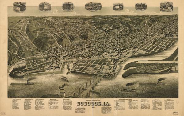
| Historical Context: Students will analyze imagery in a Civil War era map of Dubuque to discover what natural resources are available in Iowa and how those natural resources are used. Many Iowan towns were developed near water sources, starting along the Mississippi River moving west. Fertile land encouraged people to settle in Iowa as farming was (and is) a profitable industry. Wooded areas in Iowa created a lumber industry as well as a fur-trading from the animals that lived there. There are also over 100 mines in Iowa for coal, lead, and other minerals. Currently, wind power is the largest source of electricity generation in the state. Dubuque is Iowa's oldest established city founded when the United States government took ownership of land in 1833 from the Meskwaki American Indians. The city's lead mines allowed banks and other businesses to flourish. Irish and German immigrants moved to the area, expanding all kinds of industries like mining, fur trading, logging, and meat packing. Over time, these industries significantly damaged the environment surrounding Dubuque leading to the America's River project in the late 1990s. This project transformed the Mississippi River front to share the history and culture of Dubuque which has become a popular tourist attraction. |
|
| Lesson Supporting Question | |
| Lesson Overview | Students will examine maps that depict the natural resources available in Australia, southern Africa, and Berlin, Germany. Then student will examine a perspective map of Dubuque and use the imagery of the map to learn what natural resources are available in Iowa. Finally, students will create a map of their own city to show the natural resources available around them. |
| Primary Sources Used |
|
| Resources Needed | Computer and Projector Images (attached) Worksheet (attached) – 1 per student Plain map of your city (pull this up on Google Maps) – depending on the size of your city, you may want to focus on the neighborhood around the school or one that the students will be familiar with Blank white paper – the larger the better as students will be sharing in groups Markers, Colored Penciled, or Crayons |
| Standard | |
| Lesson Target | Students will be better able to gather information from primary sources, name natural resources located across Iowa, and utilize geographic representations. |
| Lesson Themes | Environments, Types of Business and Industries |
|
| Formative Assessment (How will you use the formative assessments to monitor and inform instruction?) |
Students need to understand how natural resources are depicted on maps to create their own. Use your judgement on how to deliver this part of the lesson, a game of I Spy could help students if they are not finding items are their own., Monitor students as they create their own maps to ensure they are headed in the right direction. Your students may need more time to finish their maps. |
| Summative Assessment (How does the lesson connect to planned summative assessment(s)?) |
Quality of the maps created by the students can be used to assess their understanding. If at least 2 natural resources are accurately depicted, then this lesson was a success. |
| Author | Shelby Nelsen | Created | Last Edited | ||||
| Reviewer: N/A | |||||||
| Lesson Plan Development Notes: developed by a museum educator | |||||||


