Iowa Compared to the World
| Grade | 6th Grade | Class | Social Studies | Length of Lesson | 3 Days |
| Lesson Title | Iowa Compared to the World |
| Unit Title | |
| Unit Compelling Question | What are the impacts on people if a resource runs out or is no longer available or affordable? |
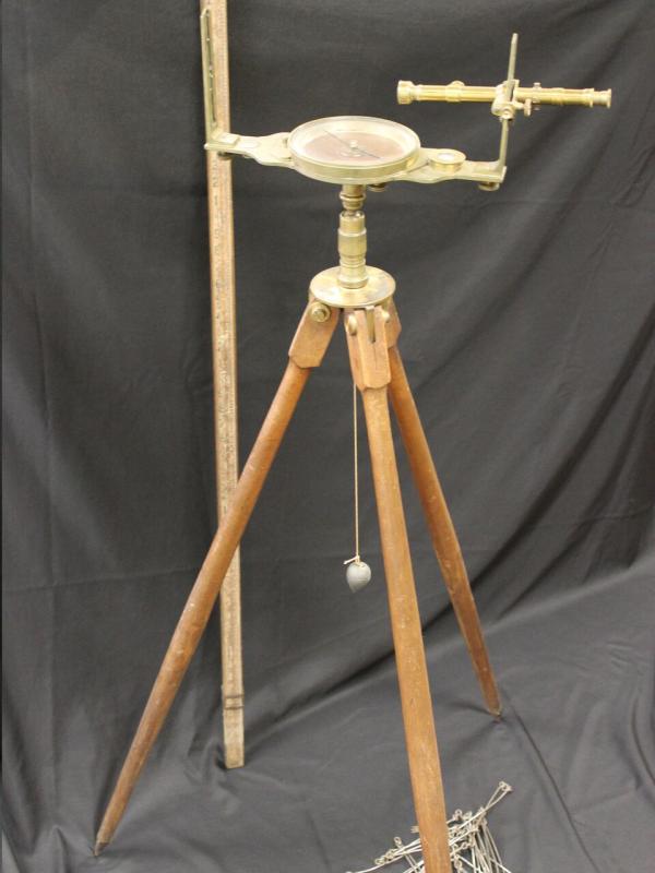
| Historical Context: Millions of years ago Iowa was covered by water. The shells of the sea creatures that lived in the ocean became limestone, which was later quarried for buildings. As the water pounded against rocks, sand was created, which later hardened into sandstone which is still visible along the Mississippi River in Clayton County. Over time the climate and landscape of Iowa has changed multiple times, including times of tropical climate and times of bitter cold. During Ice Ages, glaciers spread all across Iowa. Each time they melted the landscape was impacted, leaving bluffs, gorges, and deposits that changed into the black soil. This surveyor's compass, in the collection of the Grout Museum District, was used by Charles Mullan, one of earliest settlers of Waterloo, Iowa. Charles was an early businessman, the first justice of the peace and served as the settlement's first postmaster in 1851. He also surveyed the area and mapped out its roads, lots, and boundaries. Mullan also made the decision to name the settlement Waterloo. A surveyors compass would be used to note the direction when mapping a location. A tripod stand allowed the compass to stand on its own making it easier to write without holding a compass. Charles Mullan was born in Eckland, Pennslyvania in 1811 and came to Iowa in 1846 and settled in the area now known as Waterloo. At the time, only two other settlers, G.W. Hanna and William Virden, were residing in the town. Mullan served as the county's first justice of peace as well as the first county surveyor, where he mapped out the county''s streets, boundaries and landmarks. Mullan and his family lived in Waterloo for 28 years, where they experienced the expansion of railways through the state as well as the Civil War and the impact it had on the town. |
|
| Lesson Supporting Question | |
| Lesson Overview | |
| Primary Sources Used |
|
| Resources Needed | |
| Standard | |
| Lesson Target | Students will understand that the natural resources, geography, and climate is different in different locations. |
| Lesson Themes | Environments, Plants & Animals |
|
| Formative Assessment (How will you use the formative assessments to monitor and inform instruction?) |
Students will work in groups to create a PowerPoint presentation or video showing what they have learned about natural resources, geography, and climate between Iowa and the rest of the world. This will allow them to interpret information and be able to compare and contrast ideas., An exit card will be given to students asking them to share their understandings from the lesson at the end of each day. |
| Summative Assessment (How does the lesson connect to planned summative assessment(s)?) |
Students will be able to compare and contrast the natural resources, geography, and climate between Iowa and other parts of the world. The students will be taking the role as a researcher. The relevant audience is anyone learning about the natural resources, geography, and climate of Iowa and other parts of the world. The challenge involves students to be able to analyze information and think critically and identify similarities and differences between Iowa and other parts of the world. Students will develop a project reflecting on all of the information they have researched. |
| Author | Alexis Johnson | Created | Last Edited | ||||
| Reviewer: Dr. Lisa Millsaps, University of Northern Iowa | |||||||
| Lesson Plan Development Notes: Teaching Methods, University of Northern Iowa, Fall 2018 | |||||||


