Railway System in Iowa in the 1800's
| Grade | 7th Grade, 8th Grade | Class | Iowa History | Length of Lesson | 50 Minutes |
| Lesson Title | Railway System in Iowa in the 1800's |
| Unit Title | Transportation in Iowa |
| Unit Compelling Question | What is the lasting impact of transportation in Iowa? |
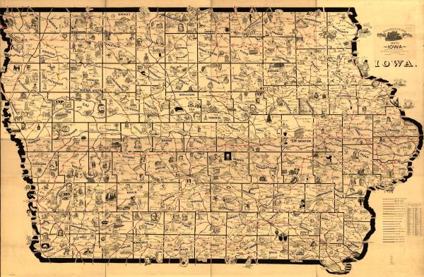
| Historical Context: 2018.056.001 One of eight large-scale pictorial maps of midwestern states showing routes and post offices of the Railway Mail Service. Designed by Chicago railway mail clerk Frank H. Galbraith to help employees of the Railway Mail Service quickly locate counties and post offices. The maps were rented for practicing or prospective workers who numbered over 6,000 and traveled over a million miles a year on the rails sorting mail. A printed title cartouche accompanied by a list of counties for each of the states by McEwen Map Company of Chicago is pasted on the maps. |
|
| Lesson Supporting Question | |
| Lesson Overview | A brief history on the railway system first expanding into Iowa, including the motivation for the expansion and the effects that the railway systems had. Then, an introduction to the Galbraith railway map, followed by two activities using the map. Finish with an exit ticket. |
| Primary Sources Used |
|
| Resources Needed | https://docs.google.com/presentation/d/1Vv47Tc51olCIr_Cccq0fa9kd_JYBt0Sj2xH3BZRlXgY/edit#slide=id.g35f391192_00 Computer Projector Paper Writing utensils Tape Scissors http://www.iptv.org/iowapathways/mypath/railroads https://www.loc.gov/resource/g4151p.rr002200/?r=-0.255,0,1.509,0.654,0 https://docs.google.com/document/d/15UoWA_7Qb1_FBNjBInjBSh0Bcxe3AuE8DjHf62Mtgbg/edit |
| Standard | |
| Lesson Target | Students will be able to identify the motivations of building railways in the Midwest.;Students will be able to identify the impact the railway had on Iowa in the 1800's.;Students will be able to explain how to get from one town to another using the Galbraith map.;Students will be able to illustrate town names based on the Galbraith style.;Students will be able to locate towns on an older map based on their location on a modern map. |
| Lesson Themes | Rail |
|
| Formative Assessment (How will you use the formative assessments to monitor and inform instruction?) |
Activity 2 - Asking students for features from the Galbraith map to see what it is that the students found most important/interesting., Activity 3 - Request a few students to share how they would get from one location to another to get a sampling of how well the class is interpreting their maps. Also check a sampling of these when they are turned in as the exit ticket., Activity 4 - Have students post their illustration on the projected map to see that they can relate the modern-day map to the Galbraith map. |
| Summative Assessment (How does the lesson connect to planned summative assessment(s)?) |
Closing - Exit ticket to see that they have identified at least one motivation and one effect of having the railway system in Iowa. |
| Author | Ashlin Hayungs | Created | Last Edited | ||||
| Reviewer: Chad Christopher, History Education, University of Northern Iowa | |||||||
| Lesson Plan Development Notes: Teaching Methods, University of Northern Iowa, Spring 2019 | |||||||


