What Does My City Look Like?
| Grade | Kindergarten | Class | Social Studies | Length of Lesson | 40 Minutes |
| Lesson Title | What Does My City Look Like? |
| Unit Title | Where am I in the World? |
| Unit Compelling Question | What does my city, my state, my country, and my world look like? |
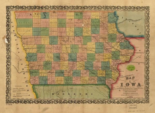
| Historical Context: Maps are a useful tool. The earliest map was made on a Babylonian clay tablet. Some maps were carved in wood. Seafaring ships needed navigation charts, encouraging the growth of the map making industry. When people traveled they took detailed notes to create useful maps. The first world map was created about the time of Columbus' voyages. Following World War I aerial photography began to be used in mapping the earth. Because the earth changes, and boundaries change, maps are frequently revised. Maps from long ago are different than maps today. Today people carry maps on their phones. Voice activated commands help drivers navigate from place to place. ~ Allyson Simpson, Simpson College 2018.056.010 Map of Iowa exhibiting the townships, cities, villages post offices, railroads, common roads & other improvements. In 1844, when the population of the soon-to-be Iowa territory was growing, the decision was made to move towards statehood. Governor Lucas, along with politicians, met in Iowa City to draft a constitution and form state boundaries. Original boundaries reached farther North to Minneapolis and the western border further east. The borders were changed after protest from the public to our borders today. On December 28, 1846, President James K. Polk signed in Iowa as the twenty-ninth state. The population grew drastically over the next few years, from 96,000 in 1846 to 518,000 in 1856. Counties were developed that measured close to 24 miles on each side. The first two counties were Dubuque and Des Moines (of a much larger size than today) that were then divided into smaller parts in 1837, prior to statehood. By 1851, the state had 89 counties. Today, the state has 99 counties. |
|
| Lesson Supporting Question | |
| Lesson Overview | Students will learn about where they live in the world. We will be listening to a song called “Where We Live” and reading part of the student text to gain more knowledge in where each person lives. We will be focusing a lot on our town and what makes us part of our town. How we not only live in a town but also live in a family and a neighborhood. It’s very possible to live on many things at once, so mentioning state, country, and world. Students will have the opportunity to look at maps and talk with peers to gain more insight of where they live. |
| Primary Sources Used |
|
| Resources Needed | |
| Standard | |
| Lesson Target | Students will identify one's own city and state and locate them on a map. |
| Lesson Themes | |
|
| Formative Assessment (How will you use the formative assessments to monitor and inform instruction?) |
Be able to see who has an idea of their city and state by the checklist that we will complete as a class. I will have a clear understanding if they get that we can live in several different places at one time. Depending on what they check I will get an understanding of what they understand and what they may need further instruction on. |
| Summative Assessment (How does the lesson connect to planned summative assessment(s)?) |
The summative assessment will be a drawing worksheet. |
| Author | Allyson Simpson | Created | Last Edited | ||||
| Reviewer: Dr. Chad Timm, Simpson College | |||||||
| Lesson Plan Development Notes: Social Studies Methods, Simpson College, Spring 2019 | |||||||


